Canoeing & Kayaking
in the Connecticut Lakes
Region, Pittsburg NH
Canoeing & Kayaking
in the Connecticut Lakes
Region, Pittsburg NH
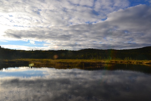
Pittsburg, New Hampshire is a paddler's paradise - canoe or kayak beautiful East Inlet, Moose Falls Flowage, the Connecticut River, or the Connecticut Lakes!
There is not only great still water paddling in Pittsburg on the bogs and lakes, but we also have some good river paddling, usually in the Class I - III range. Also, don't forget to check out the Northern Forest Canoe Trail, a network of classic rivers linking New England, New York and Quebec!
Coon Brook Bog, Pittsburg NH
Connecticut River
Paddling Maps
Canoeing & Kayaking
the Connecticut River
For Kayak/Canoe Rentals & Shuttle Service on the Connecticut River
south of Canaan, VT, please contact: Columbia Bridge Adventures
Kayaking the Connecticut River in Pittsburg can be rewarding and challenging. The river from the town of Pittsburg south to Beecher Falls, Vermont is only considered Class I and II, but it is very rocky and requires proper water levels for a good float. Based on our experience, the best conditions occurred when the discharge from Murphy Dam at Lake Francis was at least 450 CFS. We tried it once when it was 800 CFS, and that was almost too much water at the time.
The trip itself has its share of riffles and pleasant rapids, but the river becomes very challenging once it hits Beecher Falls. For a short time, the river attains Class III status as it boils and churns down a stretch of rocky falls to Canaan, Vermont. This is a great trip to undertake for more experienced kayakers, and obviously can only be done under the right conditions. Click here to check on the current river flow out of Murphy Dam!
The following has been extracted from "Canoeing on the Connecticut River", a publication now out of print. For the latest tips on navigating the Connecticut River, check out the website for the Connecticut River Joint Commissions. Another resource guide for canoeing enthusiasts covering the river from Pittsburg to the Massachusetts border would be the Appalachian Mountain Club's publication on the subject.
Before you begin your canoe trip...
Never camp or build a fire on private land without first asking permission of the landowner. The motto, "leave only footprints and take only photos" should be the rule for all those who canoe the river.
It is important that those canoeing on the river scout sections that can be hazardous at certain times of the year. When in doubt, portage around the obstacle. Safety should always be paramount. Flows are generally regulated and fluctuate seasonally, daily, and at times, hourly.
The law requires that each vessel carry a Coast Guard approved type I, II, or III personal flotation device (pfd) for every person on board. It is advisable that the pfd be worn when canoeing.
It is also recommended that you not canoe alone and that a float plan be left with a responsible person. A float plan lets others know where and when you put in, your intended stops, and the place and time you intend to take out.
About the River
The Connecticut River, at 410 miles long, is the longest river in New England. It begins high in the mountains of northern New Hampshire near the Canadian border and winds its way south to Long Island Sound.
Along the way it drains 11,260 square miles of land.
The Connecticut has a rich history as a route of exploration and later of settlement in the days when wilderness surrounded the river and the only feasible way to travel and transport goods was by water. Still later its water and that of its tributaries helped fuel the Industrial Revolution.
The Connecticut River is a natural treasure that provides both recreation and energy. There are currently 17 dams on the river and the remains of three others that have been breached. New England Power Company owns eight of those between the source and the Massachusetts border.
The Source
To get to the river's source at Fourth Connecticut Lake you must hike along the US/Canadian border.
For more information, click here.
Canoeing The River
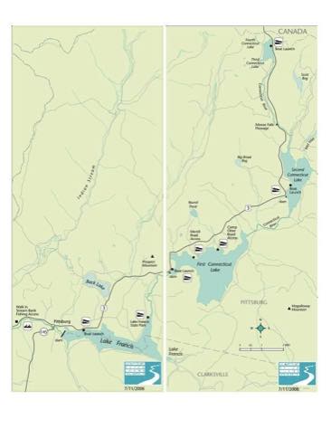
The river is generally not suitable for canoeing in the town of Pittsburg, but the four lakes, Third, Second, First and Francis provide enjoyable flatwater canoeing and excellent fishing and nature watching. Each has public access.
Most downriver canoeing begins in Canaan, VT just below the Route 114 bridge.
Supplies can be purchased close to the river in either Canaan or West Stewartstown, NH. There are a few riffles below the bridge and then the river meanders for several miles with many nice sandbars that make excellent places to stop and picnic or swim.
The distance from Canaan to the Colebrook/Lemington Bridge is about 13 miles.
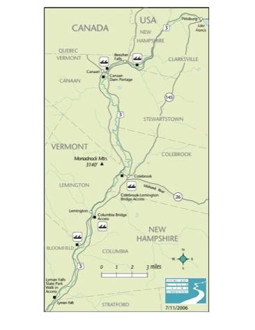
Looking to the right, you will see Mt. Monadnock which rises 3,140 feet above the valley on the Vermont side. A 2.4 mile trail leads to Mt. Monadnock from Route 102 just above the bridge. The summit provides excellent views of the valley and the Presidentials to the southeast.
A short walk from the bridge will bring you to Colebrook, NH and all the services that a medium sized town can provide.
It is five miles downstream from the Colebrook Bridge to the covered bridge connecting Columbia and Lemington. The river alternates between smooth water and easy rapids.
The river splits behind an island a half mile above the Columbia Bridge. A paddle to the left side will provide solitude, but watch out for low hanging branches.
Below the covered bridge is about two miles of flat water, followed by nine miles of intermittent rapids. Care should be taken in this section to watch for boulders and for the remains of old timber cribs.
Eight miles below the Columbia Bridge there is a dangerous section
containing the breached remains of an old dam that requires caution.
Lyman Falls is very hard to see from a canoe and problems can arise. The most obvious sign of the old dam is a block of concrete approximately four feet high and eight feet wide near the Vermont shore.
Upon spying the concrete, pull ashore and scout ahead.
The dam, once a combination of timber crib and concrete, is nearly all gone. At times canoes can run the river on the New Hampshire side, but low water may prevent such navigation. Just below the surface are the remains of the dam and many large spikes and pieces of reinforcing steel that can tear holes in a canoe.
Lyman Falls Dam is three miles from the Route 105 bridge connecting Bloomfield, VT and North Stratford, NH. The river is strewn with large boulders and care should be taken.
Fishing is restricted to catch and release by flies or artificial lures with barbless hooks from a point 250 feet below the Lyman Dam to a point 1600 feet upstream of the Bloomfield/North Stratford bridge.
Food and supplies can be purchased on either side of the bridge. This is a good place to put in or take out canoes.
The Nulhegan River enters the Connecticut on the Vermont side just below the bridge.
About a mile downstream is a bit of fast water called the "Horse Race." High on the bank on the Vermont side are the remains of the Brunswick Mineral Springs.
CONTACT US
Tall Timber Lodge
& Rainbow Grille
609 Beach Rd.
Pittsburg, NH 03592
Tel: 800-835-6343 /
603-538-6651
Fax: 603-538-6582
Contact Us
©2024 Tall Timber Lodge
ACTIVITIES